
Select Projects: UTILITIES - ELECTRICITY and WATER
GIS TECHNOLOGY BASED MANAGEMENT FOR POWER TRANSMISSION GRID
Client: National Power Transmission 4 | Duration: November 2018 – On-going | Location: Vietnam
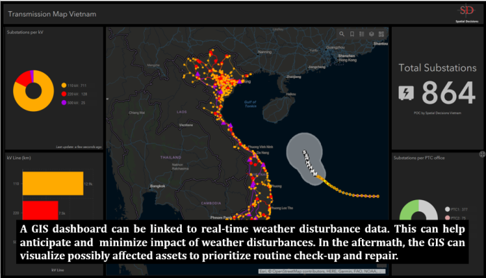
About: NPT’s goal is to deploy an Enterprise-GIS is for managing and operating the transmission grid at present, as well as to facilitate the planning, building, and operating smart transmission in the age of Industry 4.0.
The project is designed to provide direction to the use of “GIS technology-based technical management for power transmission grid” for the National Power Transmission Corporation. Its implementation will cover (i) NPT’s headquarter; (ii) PTCs, PMBs, and NPTS’s office; (iii) Operation management centers, related teams of PTCs, PMBs, and NPTS; and (iv) 220-500kV substations and transmission lines managed by PTCs.
The overall goal of the project design and implementation is to enable the National Power Transmission Corporation (NPT), a member of Electricity of Vietnam (EVN), to deploy a Geographic Information System(GIS) over NPTs service territory.
Services provided include;
-
Working with the NPT and the experts deployed for this project, we will deliver the following services:
-
Overall project coordination
-
Client and project experts management
-
Project technical support
-
Develop training, materials, and summary feedback of understanding of GIS
-
Assessment of NPT business workflow and business challenges to be addressed using Enterprise GIS
-
Assessment report of current IT, Communications, and Security of NPT and propose what is needed to support Enterprise GIS
-
Prepared Feasibility Report
-
Assessment report on identifying and applying Enterprise GIS to NPT to manage and operate the transmission grid
-
Developed a five (5) year road map of modernization of Enterprise GIS for NPT
-
Prepared detailed draft documents for procurement/bidding document for next stage
WEB-GIS BASED SEWAGE TREATMENT PLANTS INFORMATION SYSTEM
Client: M/s Sanjay Gupta and Associates | Duration: Nov 2017 – Marc 2018 | Location: New Delhi, India
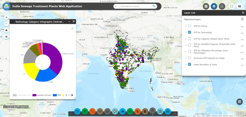
About: Sewage treatment is the process of removing unwanted contaminants from wastewater. The wastewater mostly is generated by residential, industrial, and commercial establishments. India has thousands of sewage treatment plants (STPs) spread across its topography and managing and extracting key information about these STPs can be a tall order.
The main purpose of the project is to develop Web GIS applications for viewing and modifying information on sewage treatment plants spread throughout India. These web map applications are designed to be viewed at any time, anywhere on any device by anyone with proper access. This allows for better understanding of the data, observing patterns or phenomenon which may not be as visible reading between table records. Having this kind of tool at their disposal, decision-makers will be able to better strategize their projects and operations.
The Web GIS application was developed by Spatial Decisions to serve as a visual medium in viewing critical information about sewage treatment plants spread throughout India.
Under the GIS services provided, the work included:
-
Managing and cleaning tabular data to be used for creating the STP points.
-
These tables contain essential information about each sewerage treatment plant such as absolute locations, the technology used, capacity, threshold, and status, among others.
-
Creation of GIS database and maps
-
Proper symbolization based on STP Status, Capacity, Technology, etc.
-
Publishing map services and configuring capabilities as a precursor for creating the web maps
-
Creating two aesthetically pleasing, informative web GIS applications. One web GIS application was designed for viewing and editing information such as adding new STPs or modifying information on existing ones. Another one was designed for viewing and querying features using configured tools, filters, and widgets.
-
Creating easy to follow instruction manuals and presentation materials for the clients

RESTRUCTURED ACCELERATED POWER DEVELOPMENT AND REFORM PROGRAM (R-APDRP) PROJECT: PILOT STUDY FOR DHORAJI TOWN IN THE STATE OF GUJARAT, INDIA
Client: Petro IT Limited | Duration: June 2010 – July 2010 | Location: Dhoraji, Gujarat, India
About: Dhoraji is a large and flourishing town on the banks of the small river Safura, a branch of the river Bhadra. Dhoraji is a city and a municipality in Rajkot district in the state of Gujarat, India. The aim of electric network mapping is strengthening and up-gradation of the sub-transmission, and distribution system in the country with the following objectives: reducing aggregate technical and commercial (AT&C) losses; improving quality of supply of power; increasing revenue collection; and improving consumer satisfaction
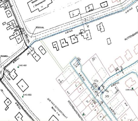
This project required GIS mapping of electrical assets i.e. high-tension pole, high-tension line segment, transformer, DTR, fuse, primary meter, switch, low-tension pole, and low-tension line segment for Dhoraji town, Gujarat. Field data have been collected as per the R-APDRP standard data model, and these data to be linked in the all-electrical asset. In this project consumer, indexing is also surveyed and mapped. After the survey and mapping of all electrical assets and consumer location/indexing, we generated the topology and geometric network connectivity in the ESRI ArcGIS 9.3 environment.
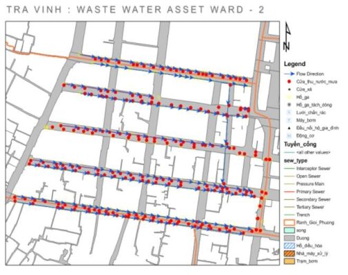
TRAINING PROGRAM: WASTEWATER AND SOLID WASTE MANAGEMENT IN PROVINCIAL CENTRES
Client: GIZ | Duration: Dec 2011 – April 2012 | Location: Hai Duong, Vinh, Soc Trang, Tra Vinh – Vietnam
About: “Wastewater and Solid Waste Management in Provincial Centers” is a program funded by the German government and jointly implemented by different institutions of the Government of Vietnam and several German Development Cooperation (GDC) agencies. The overall goal of the Wastewater and Solid Waste Management program is the enhancement of environmental conditions through the provision of improved wastewater facilities, comprehensive and efficient wastewater management, improving customer services, and gradual changes of community awareness and behavior patterns.
After the initial establishment of software components and capacity building, it was found a further training is required to keep the sustainability of the Asset Documentation Units. The basic purpose of this component is to give hands-on training in the field and office. This training program also serves as a platform to redress any software customization-related issues.

WASTEWATER AND SOLID WASTE MANAGEMENT IN PROVINCIAL CENTRES
Client: GIZ | Duration: Jan 2010 – Oct 2011 | Location: Hai Duong, Vinh, Soc Trang, Tra Vinh – Vietnam
About: “Wastewater and Solid Waste Management in Provincial Centers” is a program funded by the German government and jointly implemented by different institutions of the Government of Vietnam and several German Development Cooperation (GDC) agencies. The overall goal of the Wastewater and Solid Waste Management program is the enhancement of environmental conditions through the provision of improved wastewater facilities, comprehensive and efficient wastewater management, improving customer services, and gradual changes of community awareness and behavior patterns. The Technical Component (TC) is supporting the establishment of Asset Documentation Units (ADU) in all six participating wastewater companies. Within that scope, guidelines for purchase of hardware, development of software and subsequent field and office-based training, and capacity building are done to assist successful implementation of ADU in 4 wastewater companies from the 6 identified ones.
Services provided include:
-
Prepare an Assessment Report, based on the assessment of the existing situation of asset documentation in the participating Wastewater Companies.
-
Preparation of technical specifications for the hardware as a list of equipment which is required by the GIS-based software.
-
Preparation of technical specifications for the GPS Device which is required by the GIS-based software.
-
Preparation of suitable base maps for situational awareness in the final software.
-
Develop and refine a Database Schema to be used for storing Geo-spatial information in Asset Documentation.
-
Develop GIS-based software for asset documentation and management.
-
Installation of GIS-based software for asset documentation.
-
Training and capacity building for the ADU staff of the 4 wastewater companies.
STUDY ON IMPROVEMENT OF WATER SUPPLY SYSTEM OF DELHI
Client: Tokyo Engineering Consultancy | Duration: May 2009 – September 2009 | Location: New Delhi, India
About: Even though Delhi has access to adequate availability of water as well as sufficient treatment capacity, the actual service performance is poor. To identify the core issues confronting the sector, DJB had recently commissioned the Delhi Water Supply and Sewerage Project Preparation Study with funding from International Bank for Reconstruction and Development. DJB should move towards a much higher level of customer satisfaction and at the same time increase greatly the efficiency with which its services are delivered. The institutional and administrative changes needed to achieve this are mentioned elsewhere in this Study. For water supply customers, the crucial areas are availability and cost of water.
-
An efficient and effective water supply service meeting levels of service comparable to best practice.
-
Customer-oriented.
-
Affordable and sustainable round-the-clock (24/7) water supplies.
GIS services carried out for the project are;
-
Base map at varying scales incorporating administrative boundaries & background information from Survey of India topographic sheets, tourist maps, and satellite available.
-
Base map with administrative & service area boundaries along with water treatment facilities and distribution network.
-
Pipeline route map with background features derived from Survey of India maps and from Satellite imagery.
Planning Services:
-
Population projection for all the Water Supply Zones
-
Water Demand Projection for the Year 2011 & 2021


AGRA WATER SUPPLY GANGA JAL PROJECT
Client: NJS Consultants Limited | Duration: April 2009 – March 2010 | Location: Agra, India
About: The objective of this project is to provide safe and reliable water supply service by constructing aqueduct facilities to Agra and the surrounding area, by using an irrigation canal of the Ganges River as a water source, and by improving and expanding existing water facilities in the city of Agra in the state of Uttar Pradesh in northern India, thereby contributing to the improvement of the living conditions of residents, including the poor.
The main considerations for the project design are effective utilization of water resources through measures as reduction of water leakages and water-saving; financial soundness of service delivery agencies through measurement as raising tariff level sufficient to cover operation and maintenance cost, review of tariff collection; improvement of service delivery agencies capacities through measures of training, review of standards and manuals, improvement of customer relations, strengthening of the sections in charge of human resources and public relations and reinforcement of the information system; adequate service delivery to the poor living in slum areas and enhancement of public awareness of local inhabitants on water and environment and promotion of the private sector’s participation such as entrustment of the operation and maintenance to private companies.
The broader objectives defined under the project are as mentioned below:
-
Create the GIS-based database of water supply distribution network up to each household connection in Agra city
-
Designing & Development of GIS-Based MIS for UP Jal Nigam for managing the Digital data
-
Developing Capacity Building for UP Jal Nigam Officials in managing the GIS-Based database & GIS/MIS System
In the initial phase, the focus is on the GPS-based field surveying and mapping of distribution water network assets lying in Agra town connected to each household, while incorporating information provided by the UP Jal Nigam people with their local knowledge. To this NJS Consultants team identified the assets on the drawings provided by UP Jal Nigam for which the GPS-based survey has to be carried out. Subsequently, a pilot survey was conducted to check the accuracy of the information collected during the survey and the information provided by the UP Jal Nigam officials to set up the procedures and standards.
In the second stage, GIS-Based MIS will be designed & developed for official usage by UP Jal Nigam. All the GIS data developed during the initial phase will be incorporated into the GIS/MIS System.