GIS MAPPING SUPPORT FOR ANIMAL/HUMAN AND ANIMAL/ANIMAL INTERFACE ISSUES AND RISK FACTORS ASSOCIATED WITH DISEASE
Client: CARE Vietnam | Duration: March 2010 – June 2010 | Location: Vietnam


Client: CARE Vietnam | Duration: March 2010 – June 2010 | Location: Vietnam
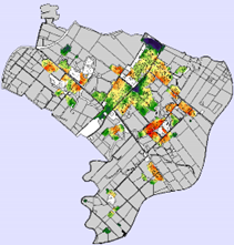
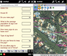
In order to understand Animal/Animal and Animal/Human interface issues and risk factors associated with the spread of diseases, a commune-level household survey was planned. The survey planned to use a mobile GIS application for attribute and location data collection. The data thus collected was integrated with a database for further statistical and geostatistical analysis. A fuzzy suitability analysis was performed to understand the vulnerability section of the commune to the risk of spread of diseases. The suitability analysis was performed using cartographic modeling tools in ArcGIS. Some of the factors considered relevant to the estimation of vulnerability include population density of vector and host, behavioral and cultural practices, animal husbandry practices, and proximity.
Specific tasks included: